Monitoring Programs
Monitoring Programs
The Walla Walla Valley River Basin is approximately 1,760 square miles, with an underlying shallow alluvial aquifer of 200 square miles. Many farmers, businesses, and residents use water from the shallow aquifer making it a highly important source of water for Walla Walla Valley. In addition to supplying wells with groundwater, the shallow aquifer also feeds the springs, streams, and rivers of the Walla Walla Basin. The high connectivity between the shallow aquifer and surface water bodies is important in enhancing base flow and, during the summer, cooling water temperatures for threatened salmonid species in the Walla Walla River Basin.
Streamflow
Streamflow
The Walla Walla Basin Watershed Council began its small-order stream and spring monitoring program in 2002 after the agreement to leave base flows in the main stem of the Walla Walla river went into effect. This network's purpose is to provide the community with supplemental water flow data, which can aid the management of the valley's water and support or assuage the fears of the concerned water users. The Walla Walla Basin Watershed Council currently monitors about 25 sites in the Walla Walla Valley, including springs, small-order streams, and irrigation ditch sites. This monitoring network covers an area bounded by Walla Walla, Milton-Freewater, and Touchet.
The WWBWC also maintains near-real-time gauge stations on the main stem of the Walla Walla River below Tum-A-Lum Bridge as well as stations on the South and North Forks of the Walla Walla River above the forks confluence.
VIEW HISTORICAL STREAMFLOW LOCATIONS AND DATA
Groundwater
Groundwater
For many years, the volume of water being pumped out of our aquifer has exceeded the amount of water recharging it. This has left our shallow alluvial aquifer in a state of decline. Since 2001, the Walla Walla Basin Watershed Council (WWBWC) has tracked water levels in a network of shallow monitoring wells (250 feet or less) in the Walla Walla Basin as part of long-term efforts to understand this shallow, unconfined, aquifer. The WWBWC currently monitors over 60 wells in the Walla Walla River Basin and has records of over 100 wells with historic data. Groundwater monitoring data has informed projects to mitigate aquifer decline and groundwater management decisions in the basin.
The shallow well monitoring network is a grassroots, community effort led by the WWBWC, and includes both urban and rural wells in and around Milton-Freewater and Umapine. They are owned by a variety of water users, including states, counties, cities, businesses, and universities within the basin. However, most monitoring wells are irrigation or old domestic wells owned by private landowners. All the participating well owners do so voluntarily, aiding in the effort to understand and mitigate the decline of the aquifer: a critically important resource to the entire Walla Walla Valley community. We are incredibly thankful for their participation in this task.
Water Quality
Water Quality
The WWBWC participates in several ongoing water quality monitoring programs include Walla Walla River Temperature monitoring, the Pesticide Stewardship Partnership Program (PSP), and data storage for the Creating Urban Riparian Buffers project..
VIEW WWBWC WATER TEMPERATURE LOCATIONS AND DATA
VIEW WWBWC PSP INFORMATION
Integrated Water Management
VIEW AQUIFER RECHARGE LOCATIONS AND REPORTS
The WWBWC tracks groundwater levels associated with four aquifer recharge sites in near-real time at:
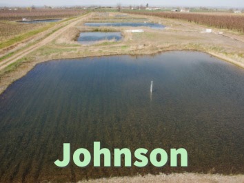
Constructed in the spring of 2004, it has since gone through two expansions resulting in the current site of almost 3 acres of spreading basins (10 spreading basins) and 3 infiltration galleries.
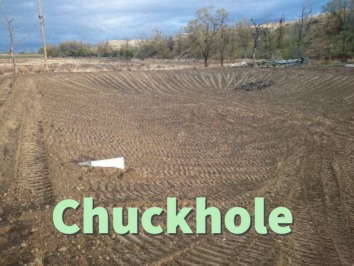
This site was constructed in the fall of 2015 and consists of a single infiltration basin with a sediment-settling pond.

Constructed in the fall of 2015, this site consists of a single infiltration basin off of the Fruitvale ditch.
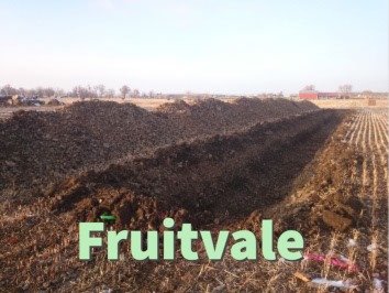
The Fruitvale Aquifer Recharge site was constructed in the fall of 2015 and consists of a series of four infiltration galleries fed by a single pipeline.