Aquifer Recharge Sites (Active)
Anspach
 |
Anspach Aquifer Recharge Site |
|
Construction Year: 2012 Recharge Seasons: 2012 - Present |
|
| Project Description | |
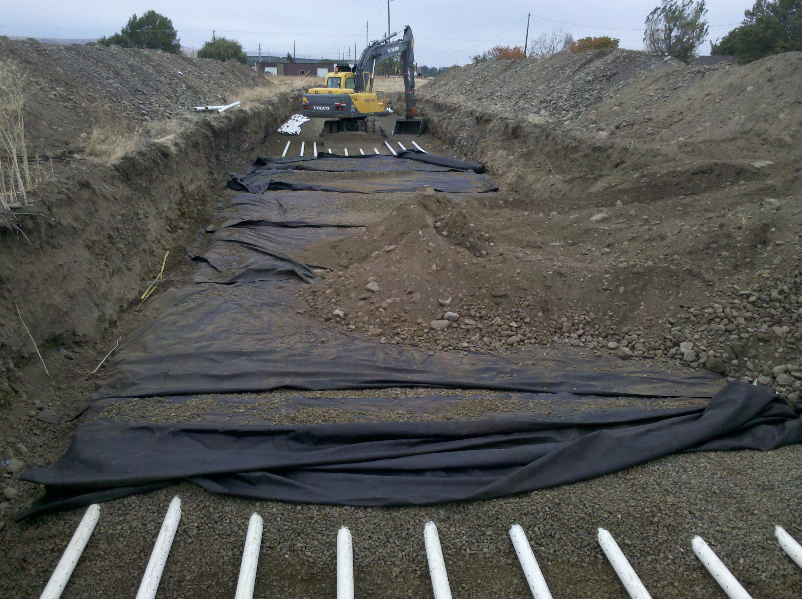
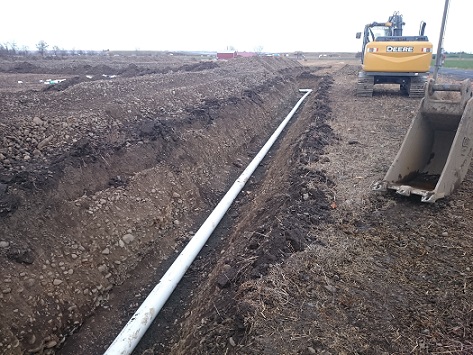
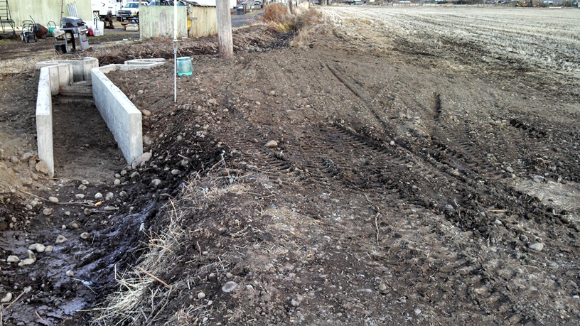
| The Anspach Aquifer Recharge site (Anspach site) was constructed in October 2012 using a combination of BPA and OWEB funding. The site consists of 10 4” perforated drain field pipes running approximately 200 feet. These pipes are buried 6-7 feet under the ground with ~1-2 foot of cleaned gravel under them and ~0.5-1 feet of cleaned gravel on top of them (for details see designs). Water for this site is delivered down the Hudson Bay District Improvement Company’s system. The water is delivered down the HBDIC’s White Ditch and then turned into a private pipeline/ditch. The site’s turnout and valve are situated along this private ditch. The site was designed to operate at a recharge rate of ~1 cubic foot per second (cfs). The site was operated for a short duration during the end of the 2012-2013 recharge season and averaged approximately 0.50-0.75 cfs. The lower than expected rate was due to limitations in the private ditch to convey more water. In addition, the recharge site is below the other users on the private ditch/pipeline and is thus influenced by their usage. | |
| Documents | Document Name | Download Documents |
| Project Designs | Click here to download | |
| Project Photos | Click here for project photos | |
| Recharge Volume by Year Chart | Click here to download photo | |
| Reports | Click here to go to reports |
| Contacts & Partners | Name | Role | Organization |
| Jon Brough | Site Construction | Hudson Bay District Improvement Company | |
| Steven Patten | Project Lead | Walla Walla Basin Watershed Council | |
| Luke Adams/Cody Grant | Site Manager | Walla Walla Basin Watershed Coincil/Hudson Bay District Improvement Company | |
| John Fazio | Project Engineer | Fazio Engineering |
| Grants & Funding | Organization | Contract # | Funding Amount |
| Bonneville Power Administration (BPA) | |||
| Oregon Watershed Enhancement Board (OWEB) | #210-6043 |
| Project Map |
|
| Aquifer Recharge Sites Map
|
Barrett
 |
Barrett Aquifer Recharge Site |
|
Construction Year: 2014 Recharge Seasons: 2013 - Present |
|
| Project Description | |
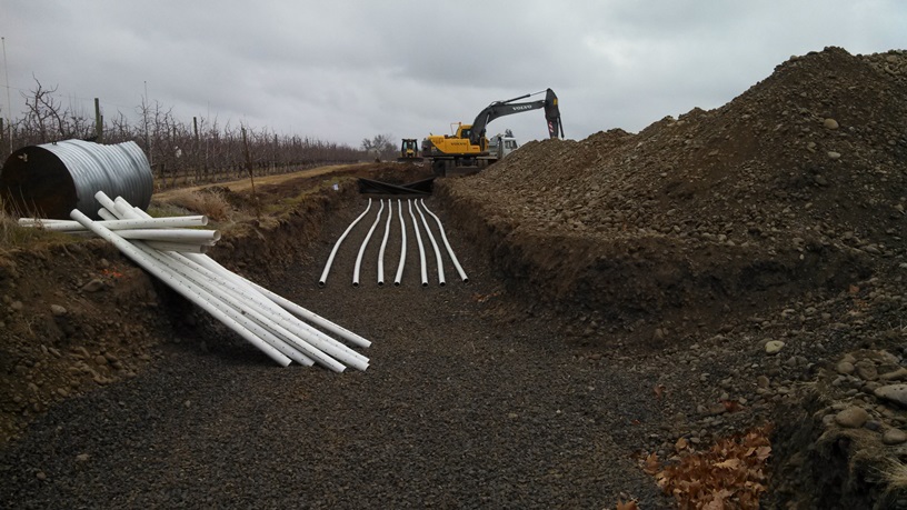
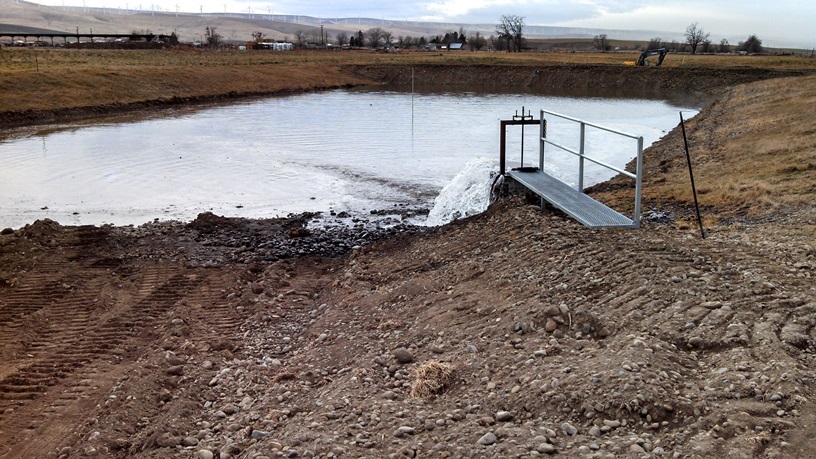
| The Barrett Aquifer Recharge site is located just northwest of the city of Milton-Freewater, OR. The site is an infiltration gallery design with 7 4" perforated pipes running ~600 feet. The Barrett site is located parallel to the Barrett pipeline. The site was constructed in the winter of 2014. The site can recharge approximalely 1500-1800 gallons per minute (gpm) or 3.3-4 cubic feet per second (cfs). | |
| Documents | Document Name | Download Documents |
| Project Designs | Click here to download | |
| Project Photos | Click here for project photos | |
| Recharge Volume by Year Chart | Click here to download photo | |
| Reports | Click here to go to reports |
| Contacts & Partners | Name | Role | Organization |
| Jon Brough | Site Construction | Hudson Bay District Improvement Company | |
| Steven Patten | Project Lead | Walla Walla Basin Watershed Council | |
| Cody Grant | Site Manager | Hudson Bay District Improvement Company | |
| Bernard Hewes | Project Engineer | Hewes Engineering |
| Grants & Funding | Organization | Contract # | Funding Amount |
| Oregon Watershed Enhancement Board (OWEB) | #210-6043 | ||
| Project Map | |
|
Aquifer Recharge Sites Map |
Chuckhole
 |
Chuckhole Aquifer Recharge Site |
|
Construction Year: 2015 Recharge Seasons: 2016 - Present |
|
| Project Description | |
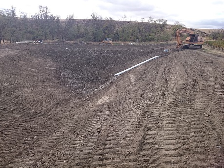
| The Chuckhole Aquifer Recharge site is located just northwest of the city of Milton-Freewater, OR. The site is an infiltration basin design with a sediment settling pond. The Chuckhole site is located near the end of the Milton pipeline. The site was constructed in the fall of 2015. The site is expected recharge approximalely 300-400 gallons per minute (gpm) or just under 1 cubic feet per second (cfs). | |
| Documents | Document Name | Download Documents |
| Project Designs | Click here to download | |
| Project Photos | Click here for project photos | |
| Recharge Volume by Year Chart | Click here to download photo | |
| Reports | Click here to go to reports |
| Contacts & Partners | Name | Role | Organization |
| Mark Johnson | Site Construction | Harry Johnson Plumbing and Excavation | |
| Steven Patten | Project Lead | Walla Walla Basin Watershed Council | |
| Sean Roloff | Site Manager | Landowner, Walla Walla River Irrigation District | |
| Lance Horning | Project Engineer | Lance Horning Engineering |
| Grants & Funding | Organization | Contract # | Funding Amount |
| Oregon Watershed Enhancement Board (OWEB) | #214-6012-10490 | ||
| Project Map | |
|
Aquifer Recharge Sites Map |
East Trolley
 |
East Trolley Aquifer Recharge Site |
|
Construction Year: 2013 Recharge Seasons: 2017 - Present |
|
| Project Description | |
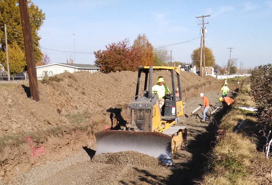
| The East Trolley Lane Aquifer Recharge site was constructed in October 2013. The project includes 4 lines of 4" perforated pipes each running approximately 600 feet along Trolley Lane. This project is expected to help mitigate for potential groundwater impacts from the Trolley Lane piping project. The project is also expected to help improve spring flows in Lewis Prong/Walsh Creek, the West Little Walla Walla River and reduce seepage loss from the West Little Walla Walla River. This project was funded by the Oregon Watershed Enhancement Board and Bonneville Power Administration. | |
| Documents | Document Name | Download Documents |
| Project Designs | Click here to download | |
| Project Photos | Click to view project photos | |
| Recharge Volume by Year Chart | Click here to download photo | |
| Reports | Click here to go to reports |
| Contacts & Partners | Name | Role | Organization |
| Don Jackson | Site Construction | Premier Excavation | |
| Steven Patten | Project Lead | Walla Walla Basin Watershed Council | |
| Luke Adams | Site Manager | Walla Walla Basin Watershed Council | |
| Lance Horning | Project Engineer | Lance Horning Engineering |
| Grants & Funding | Organization | Contract # | Funding Amount |
| Oregon Waterhsed Enhancement Board (OWEB) | #210-6043 | ||
| Bonneville Power Administration (BPA) |
| Project Map | |
|
Aquifer Recharge Sites Map |
Fruitvale
 |
Fruitvale Aquifer Recharge Site |
|
Construction Year: 2015 Recharge Seasons: 2017 - Present |
|
| Project Description | |
| The Fruitvale Aquifer Recharge site is located just northwest of the city of Milton-Freewater, OR. The site is an infiltration gallery basin design with 12 4" perforated pipes running 150' in length. The Fruitvale site is located within the Fruitvale Water Users Association system. The site was constructed in the fall of 2015. The site is expected recharge approximalely 400 gallons per minute (gpm) or just under 1 cubic feet per second (cfs). | |
| Documents | Document Name | Download Documents |
| Project Designs | Click here to download | |
| Project Photos | Click here for project photos | |
| Recharge Volume by Year Chart | Click here to download photo | |
| Reports | Click here to go to reports |
| Contacts & Partners | Name | Role | Organization |
| Don Jackson | Site Construction | Don Jackson Excavation | |
| Steven Patten | Project Lead | Walla Walla Basin Watershed Council | |
| Lee Andrews | Site Manager | Landowner, Fruitavle Water Users Association | |
| Lance Horning | Project Engineer | Lance Horning Engineering |
| Grants & Funding | Organization | Contract # | Funding Amount |
| Oregon Watershed Enhancement Board (OWEB) | 214-6012-10490 | ||
| Project Map | |
|
Aquifer Recharge Sites Map |
Gallagher
 |
Gallagher Aquifer Recharge Site |
|
Construction Year: 2017 Recharge Seasons: 2018 - Present |
|
| Project Description | |
|
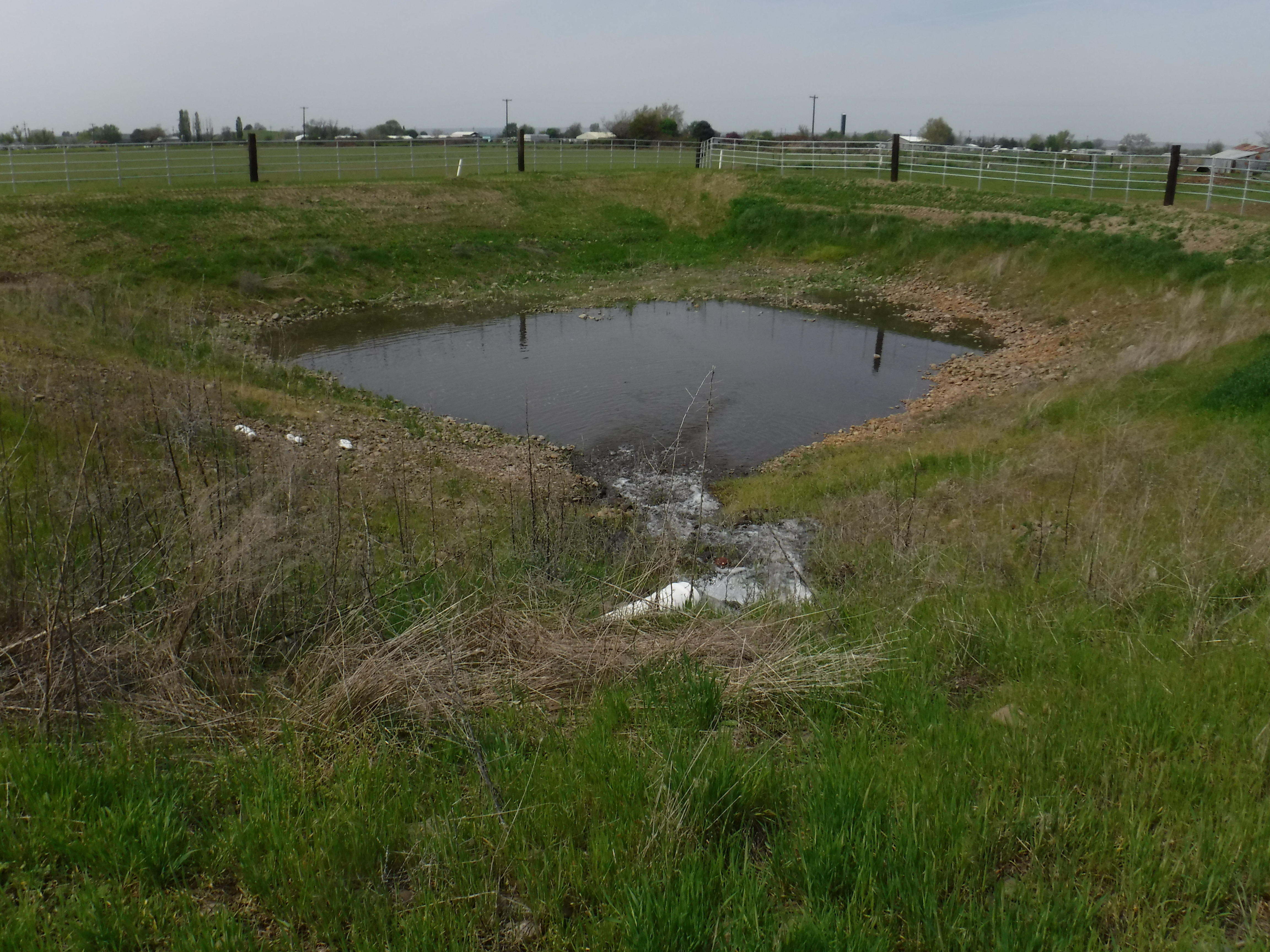
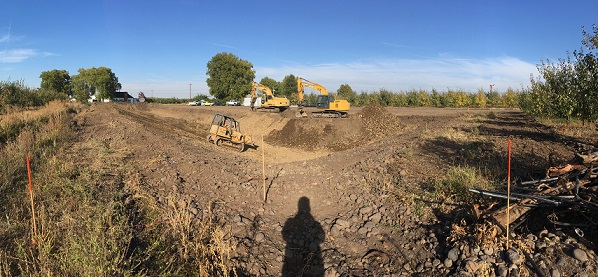
The Gallagher Aquifer Recharge Site installed an infiltration basin and an infiltration gallery (IG) along Dugger Creek approximately 0.5 miles SE of Umapine. This location was selected because of proposed irrigation efficiency work and to improve surface flows in Dugger Creek, which flows into Pine Creek a steelhead stream. The aquifer recharge project is expected to help improve flows in Dugger Creek, Pine Creek and the lower Walla Walla River as well as regional groundwater levels. As groundwater levels decline, the gradient between surface water and groundwater increases thereby increasing seepage loss from the WW River and other streams/creeks. The reverse is true as well, as groundwater levels increase, the gradient between surface water and groundwater decreases limiting seepage loss and potentially creating gaining surface flow conditions. The site can recharge approximalely 200 gallons per minute (gpm) or 0.35 cubic feet per second (cfs). |
|
| Documents | Document Name | Download Documents |
| Project Designs | Click here to download | |
| Project Photos | Click here to download | |
| Recharge Volume by Year Chart | Click here to download photo | |
| Reports | Click here to go to reports |
| Contacts & Partners | Name | Role | Organization |
| Don Jackson | Site Construction | Don Jackson Excavation | |
| Steven Patten | Project Lead | Walla Walla Basin Watershed Council | |
| Luke Adams/ Dan Tucker | Site Manager | Walla Walla Basin Watershed Council/Landowner | |
| Lance Horning | Project Engineer | Lance Horning Engineering |
| Grants & Funding | Organization | Contract # | Funding Amount |
| Oregon Watershed Enhancement Board (OWEB) | |||
| Bonneville Power Administration (BPA) |
| Project Map | |
|
Aquifer Recharge Sites Map |
Johnson
 |
Johnson Aquifer Recharge Site (Formerly known as the HBDIC Aquifer Recharge Site) |
|
Construction Years: 2004-06, 2009 & 2010-11 Recharge Seasons: 2004 - Present |
|
| Project Description | |
|
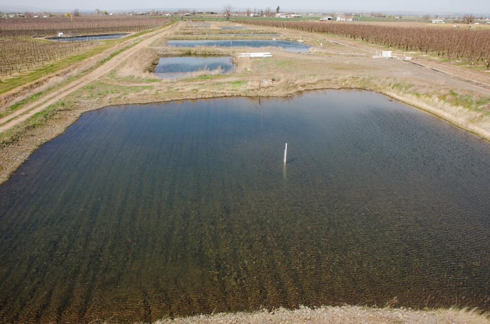
The Johnson AR site, formerly known as the Hudson Bay site, has been operating since 2004. The Johnson site has grown in three phases since operations began. The initial 2 phases are described extensively in the final report for the first limited license. The site currently has the capacity for approximately 16 to 17 cubic feet per second (cfs) of infiltration into approximately 3 acres of infiltration basins (spreading basins) and 3 infiltration galleries. Per the Oregon Water Resources Departments (OWRD) Limited License, water allocated to this project is sourced from the Walla Walla River using an irrigation diversion and canal delivery system that originates in the town of Milton-Freewater, OR. The limited license requires a minimum flow amount to remain in the mainstem Walla Walla River, water quality testing, and monitoring of local surface water and groundwater hydrology. 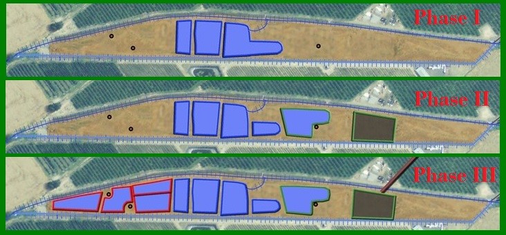
The Johnson site was originally constructed with three spreading basins. The three original basins were constructed in the winter/spring of 2004. These basins were increased in size during 2005 to almost triple their area. Phase II included adding an up-gradient spreading basin in 2006 and the addition of four infiltration galleries in the winter of 2009. Water for the new up-gradient basin was fed through the original diversion with water being “pushed” into it from the first basin. Phase III included the addition of four additional basins on the lower end of the property, a new out-flow measurement weir, a new pipeline that feeds water to each individual basin, a telemetry system to remote monitor the site and an alternate method to deliver water to the up-gradient basin. During Phase II, four infiltration galleries (IG) were installed at the Johnson site for testing purposes. IG #1 was constructed of corrugated 4” perforated pipe, IG #2 was constructed of 4” drain field pipe, IG #3 was 4” drain field pipe inside Stormtech stormwater chambers and IG #4 was drain field pipe inside Atlantis stormwater devices. During the first season of testing IG #1 clogged up and has not been utilized since. IG #2, IG #3 and IG #4 have all continued to function and have been operated during each recharge season. The four different infiltration gallery designs were installed to create a cost-benefit analysis of the different design types and to determine each design’s longevity. |
|
| Documents | Document Name | Download Documents |
| Project Designs | Click here to download | |
| Johnson Site Hydrogeologic Assessment Report | Click here to download | |
| 2005-06 Water Quality Plan | Click here to download | |
| 2008-09 Water Quality Plan | Click here to download | |
| 2013 Water Quality Monitoring Plan | Click here to download | |
| Limited License LL758 Application | Click here to download | |
| Limited License LL758 | Click here to download | |
| Limited License LL1189 Application | Click here to download | |
| Limited License LL189 | Click here to download | |
| Limited License LL1433 Application | Click here to download | |
| Limited License 1433 | Click here to download | |
| Ari Schilfgaarde Thesis | Click here to download | |
| Aristides Petrides Jimenez PhD Thesis | Click here to download | |
| Recharge Volume by Year Chart | Click here to download photo | |
| Reports | Click here to go to reports |
| Contacts & Partners | Name | Role | Organization |
| Jon Brough | Site Construction | Hudson Bay District Improvement Company | |
| Steven Patten | Project Lead | Walla Walla Basin Watershed Council | |
| Cody Grant/Luke Adams | Site Manager | Hudson Bay District Improvement Company/Walla Walla Basin Watershed Council | |
| Bernard Hewes | Project Engineer | Hewes Engineering |
| Grants & Funding | Organization | Contract # | Funding Amount |
| Oregon Watershed Enhancement Board (OWEB) | |||
| Bonneville Power Administration (BPA) | |||
| Walla Walla Watershed Alliance |
| Project Map | |
|
Aquifer Recharge Sites Map |
Locust Road
 |
Locust Road Aquifer Recharge Site |
|
Construction Year: 2016 Recharge Seasons: 2017 - Present |
|
| Project Description | |
| The Locust Road Aquifer Recharge site is located just north of the city of Milton-Freewater, OR. The site is an infiltration gallery design with 8 4" perforated pipes running 260' in length. The Locust Road site is located off of the East Branch Crockett ditch within the Walla Walla River Irrigation District. The site was constructed in the fall of 2016. The site is expected to recharge approximalely 600-800 gallons per minute (gpm) or 1-2 cubic feet per second (cfs). | |
| Documents | Document Name | Download Documents |
| Project Designs | Click here to download | |
| Project Photos | Click here for project photos | |
| Recharge Volume by Year Chart | Click here to download photo | |
| Reports | Click here to go to reports |
| Contacts & Partners | Name | Role | Organization |
| Don Jackson | Site Construction | Don Jackson Excavation | |
| Steven Patten | Project Lead | Walla Walla Basin Watershed Council | |
| Sean Roloff | Site Manager | Landower, Walla Walla River Irrigation District | |
| Lance Horning | Project Engineer | Lance Horning Engineering |
| Grants & Funding | Organization | Contract # | Funding Amount |
| Oregon Watershed Enhancement Board (OWEB) | 214-6012-10490 | ||
| Bonneville Power Administration |
| Project Map | |
|
Aquifer Recharge Sites Map |
Miller Road
 |
Miller Road Aquifer Recharge Site |
|
Construction Year: 2020 Recharge Seasons: 2021 - Present |
|
| Project Description | |
|
The Miller Road site consists of one infiltration gallery along the edge of an orchard. The Miller Road site is located east of Milton-Freewater, immediately adjacent to and north of Miller Road. Water will be delivered to the site from the Walla Walla River Irrigation District’s Eastside irrigation water delivery pipeline. The site can recharge approximalely 700 gallons per minute (gpm) or 1.5 cubic feet per second (cfs). |
|
| Documents | Document Name | Download Documents |
| Project Designs | Click here to download | |
| Project Photos | Click here to download | |
| Recharge Volume by Year Chart | Click here to download photo | |
| Reports | Click here to go to reports |
| Contacts & Partners | Name | Role | Organization |
| Don Jackson | Site Construction | Don Jackson Excavation | |
| Marie Cobb | Project Lead | Walla Walla Basin Watershed Council | |
| Luke Adams | Site Manager | Walla Walla Basin Watershed Council | |
| Donell Fluckiger | Project Engineer | Fluckiger Consulting Engineering and Environmental |
| Grants & Funding | Organization | Contract # | Funding Amount |
| Oregon Watershed Enhancement Board (OWEB) | |||
| Bonneville Power Administration (BPA) |
| Project Map | |
|
Aquifer Recharge Sites Map |
Mud Creek
 |
Mud Creek (OR) Aquifer Recharge Site |
|
Construction Year: 2015 Recharge Seasons: 2017 - Present |
|
| Project Description | |
| The Mud Creek Aquifer Recharge site was constructed in the fall of 2015. The site includes an enlarged basin within a grass pasture/wildlife area. Water for the project is delivered down the Fruitvale Ditch and then can overflow back into the Fruitvale Ditch. The site is up-gradient of the Mud Creek headwater springs and is expected to improve instream flows in Mud Creek and recover local groundwater levels. The site is expected to operate around 400-500 gpm (gallons per minute) or approximately 1 cfs (cubic feet per second). | |
| Documents | Document Name | Download Documents |
| Project Designs | Click here to download | |
| Project Photos | Click here to view photos | |
| Recharge Volume by Year Chart | Click here to download photo | |
| Reports | Click here to go to reports |
| Contacts & Partners | Name | Role | Organization |
| John Royse | Site Construction | Royse Hydroseeding & Excavating | |
| Steven Patten | Project Lead | Walla Walla Basin Watershed Council | |
| Ralph Perkins | Site Manager | Fruitvale Water Users Association | |
| Lance Horning | Project Engineer | Lance Horning Engineering |
| Grants & Funding | Organization | Contract # | Funding Amount |
| Oregon Watershed Enhancement Board (OWEB) | 214-6012-10490 | ||
| Bonneville Power Administration |
| Project Map | |
|
Aquifer Recharge Sites Map |
N. Sunquist
 |
North Sunquist Aquifer Recharge Site |
|
Construction Year: 2018 Recharge Seasons: Not yet operational |
|
| Project Description | |
|
The North Sunquist Aquifer Recharge Project installed an infiltration basin adjacent to and joining with the Fruitvale Ditch approximately 2.1 miles northeast of Umapine. The Fruitvale Ditch is within the Middle Mud Creek system. The recharge rate for this site is not yet known. |
|
| Documents | Document Name | Download Documents |
| Project Designs | Click here to download | |
| Project Photos | Click here to download | |
| Recharge Volume by Year Chart | Click here to download photo | |
| Reports | Click here to go to reports |
| Contacts & Partners | Name | Role | Organization |
| Casey Humbert | Site Contruction | Eastern Oregon Contracting, LLC | |
| Steven Patten | Project Lead | Walla Walla Basin Watershed Council | |
| Ralph Perkins | Site Manager | Fruitvale Water Users Association | |
| Lance Horning | Project Engineer | Lance Horning Engineering |
| Grants & Funding | Organization | Contract # | Funding Amount |
| Oregon Watershed Enhancement Board (OWEB) | |||
| Bonneville Power Administration (BPA) |
| Project Map | |
|
Aquifer Recharge Sites Map |
NW. Umapine
 |
NW Umapine Aquifer Recharge Site |
|
Construction Year: 2013 Recharge Seasons: 2014 - Present |
|
| Project Description | |
| The NW Umapine Aquifer Recharge site was constructed in late 2013. The site utilizes an exisiting basin within a pasture. The basin was divided in half with a berm. Water for the project is delivered down the Hudson Bay District Improvement Company's system (via the Richartz's pipeline) and then down a new ~1000 lateral pipeline to the basin. The site is up-gradient of Swartz Creek, a tributary to Pine Creek, and is expected to improve instream flows in both Swartz and Pine Creek and recover local groundwater levels. During the second half of the 2014 recharge season, the NW Umapine site was operating at approximately 2.25 cfs (~1000 gallons per minute). | |
| Documents | Document Name | Download Documents |
| Project Designs | Click here to download | |
| Project Photos | Click here to view photos | |
| Recharge Volume by Year Chart | Click here to download photo | |
| Reports | Click here to go to reports |
| Contacts & Partners | Name | Role | Organization |
| Jon Brough | Site Construction | Hudson Bay District Improvement Company | |
| Steven Patten | Project Lead | Walla Walla Basin Watershed Council | |
| Cody Grant | Site Manager | Hudson Bay District Improvement Company | |
| Bernard Hewes | Project Engineer | Hewes Engineering |
| Grants & Funding | Organization | Contract # | Funding Amount |
| Oregon Watershed Enhancement Board (OWEB) | |||
| Project Map | |
|
Aquifer Recharge Sites Map |
Ruby Lane
 |
Ruby Lane Aquifer Recharge Site |
|
Construction Year: 2017 Recharge Seasons: 2021 - Present |
|
| Project Description | |
|
Ruby Lane Aquifer Recharge Site consisits of one infiltration gallery to run adjacent to Ruby Lane which is located north of Milton-Freewater, Oregon. The gallery is installed along the edge of a vineyard, just south of Ruby Lane. Water will be delivered to the site from the West Crockett Branch of the East Little Walla Walla River. The site can recharge approximalely 30 gallons per minute (gpm) or 0.06 cubic feet per second (cfs). |
|
| Documents | Document Name | Download Documents |
| Project Designs | Click here to download | |
| Project Photos | Click here to download | |
| Recharge Volume by Year Chart | Click here to download photo | |
| Reports | Click here to go to reports |
| Contacts & Partners | Name | Role | Organization |
| Casey Humbert | Site Contruction | Eastern Oregon Contracting, LLC | |
| Marie Cobb | Project Lead | Walla Walla Basin Watershed Council | |
| Luke Adams | Site Manager | Walla Walla Basin Watershed Council | |
| Donell Fluckiger | Project Engineer | Fluckiger Consulting Engineering and Environmental |
| Grants & Funding | Organization | Contract # | Funding Amount |
| Oregon Watershed Enhancement Board (OWEB) | |||
| Bonneville Power Administration (BPA) |
| Project Map | |
|
Aquifer Recharge Sites Map |
Triangle Road
 |
Triangle Road Aquifer Recharge Site |
|
Construction Year: 2016 Recharge Seasons: 2017 - Present |
|
| Project Description | |
| The Triangle Road Aquifer Recharge site was constructed in the fall of 2016. The site is located northwest of the the city of Milton-Freewater, OR. The site is an infiltration basin design with an overflow capability back to the Fruitvale Ditch. Water for the project is delivered down the Fruitvale Ditch and then can overflow back into the Fruitvale Ditch. The site is up-gradient of the Mud Creek headwater springs and is expected to improve instream flows in Mud Creek and recover local groundwater levels. The site is expected to operate around 400-500 gpm (gallons per minute) or approximately 1 cfs (cubic feet per second). | |
| Documents | Document Name | Download Documents |
| Project Designs | Click here to download | |
| Project Photos | Click here to view photos | |
| Recharge Volume by Year Chart | Click here to download photo | |
| Reports | Click here to go to reports |
| Contacts & Partners | Name | Role | Organization |
| Mark Johnson | Site Contruction | Harry Johnson Plumbing and Excavation | |
| Steven Patten | Project Lead | Walla Walla Basin Watershed Council | |
| Casey Humbert/Luke Adams | Site Manager | Landowner/Walla Walla Basin Watershed Council | |
| Lance Horning | Project Engineer | Lance Horning Engineering |
| Grants & Funding | Organization | Contract # | Funding Amount |
| Oregon Watershed Enhancement Board (OWEB) | 214-6012-10490 | ||
| Project Map | |
|
Aquifer Recharge Sites Map |
Trumbull
 |
Trumbull Aquifer Recharge Site |
|
Construction Year: 2012 Recharge Seasons: 2013 - Present |
|
| Project Description | |
|
The Trumbull Aquifer Recharge site was constructed in October 2012 using a combination of Bonneville Power Administration (BPA) and Oregon Watershed Enhancement Board (OWEB) funding. The site consists of three 8” perforated pipes running approximately 300 feet. These pipes are buried 6 feet under the ground with ~1-2 foot of cleaned gravel under them and ~0.5-1 feet of cleaned gravel on top of them (see designs). Water for this site is delivered down the Hudson Bay Ditch Improvement Company’s (HBDIC) system. The Trumbull site’s water is sourced from the structure that splits the HBDIC canal into the Hyline pipeline and the Richardz ditch. The site has its own turnout and valve so it can operate independent of the Richartz ditch or Hyline pipeline. The site was designed to operate at a recharge rate of ~2-3 cubic feet per second (cfs). The site was operated for a short duration during the end of the 2013 recharge season and had an average recharge rate of just over 2 cfs. |
|
| Documents | Document Name | Download Documents |
| Project Designs | Click here to download | |
| Project Photos | Click here to view project photos | |
| Recharge Volume by Year Chart | Click here to download photo | |
| Reports | Click here to go to reports |
| Contacts & Partners | Name | Role | Organization |
| Don Jackson | Site Construction | Premier Excavation | |
| Steven Patten | Project Lead | Walla Walla Basin Watershed Council | |
| Cody Grant | Site Operator | Hudson Bay District Improvement Company | |
| Bernard Hewes | Project Engineer | Hewes Engineering |
| Grants & Funding | Organization | Contract # | Funding Amount |
| Bonneville Power Administration (BPA) | |||
| Oregon Watershed Enhancement Board (OWEB) | #210-6043 |
| Project Map | |
|
Aquifer Recharge Sites Map |
West Ringer
 |
West Ringer Road Aquifer Recharge Site |
|
Construction Year: 2013 Recharge Seasons: 2018 - Present |
|
| Project Description | |
| The West Ringer Road Aquifer Recharge site was constructed in December 2013. The site was funded by the Oregon Watershed Enhancement Board (OWEB). The site consists of four 60 foot runs of Infiltrator drainage product buried ~6 feet below ground surface with the native soil used as backfill. Water for this site will be delivered down the Hudson Bay District Improvement Company's (HBDIC) system and then turned into Dugger Ditch (also known as Givens Ditch). The site has a trash screen and its own valve to control water delivery to the site. The site was designed to operate at a recharge rate of ~1 cubic foot per second (cfs). | |
| Documents | Document Name | Download Documents |
| Project Designs | Click here to download | |
| Project Photos | Click here to view photos | |
| Recharge Volume by Year Chart | Click here to download photo | |
| Reports | Click here to go to reports |
| Contacts & Partners | Name | Role | Organization |
| Don Jackson | Site Construction | Premier Excavation | |
| Steven Patten | Project Lead | Walla Walla Basin Watershed Council | |
| Luke Adams | Site Manager | Walla Walla Basin Watershed Council | |
| Lance Horning | Project Engineer | Lance Horning Engineering |
| Grants & Funding | Organization | Contract # | Funding Amount |
| Oregon Watershed Enhancement Board (OWEB) | #210-6043 | $23,369 | |
| Project Map | |
|
Aquifer Recharge Sites Map |
Walla Walla Basin Aquifer Recharge Reports
Oregon Reports
2005 Hall-Wentland Water Quality Monitoring
2008-2009 Hall-Wentland Water Quality Monitoring Plan
2004-2009 Hudson Bay Recharge Report - Aquifer Recharge as a Water Management Tool
Appendix I - Laboratory Results (Water Quality Testing)
Appendix II - Limited Licenses
Appendix III - Infiltration Basin and Gallery Designs
Limited License 1433 Water Quality and Water Level Monitoring Plan
2012 Water Quality Summary Report
2013 Oregon Aquifer Recharge Report
2014 Oregon Aquifer Recharge Report
2015 Oregon Aquifer Recharge Report
2016 Oregon Aquifer Recharge Report
2017 Oregon Aquifer Recharge Report
2018 On-Farm Aquifer Storage & Recovery /Artificial Recharge & Recovery Report (with appendices - 14 MB)
2018 City of Milton-Freewater Aquifer Storage & Recovery Project Report (27mb) Drawings (12mb) Tech Specifications (1mb)
2018 Oregon Managed Aquifer Recharge Report
2019 Milton-Freewater Aquifer Storage and Recovery Project / Phase 1 Feasibility Study Final Report
2019 Hydrogeologic Investigation Eastside Milton-Freewater Aquifer Recharge and Recovery Project (13mb) Appendices
Limited License 1621 Water Quality and Water Level Monitoring Plan
Limited License 1621 Hydrogeology Setting
2019 Oregon Aquifer Recharge Final Report
2020 Oregon Aquifer Recharge Final Report
Limited License 1848 Hydrogeology Setting, Water Quality and Water Level Monitoring Plan
2021 Oregon Aquifer Recharge Final Report
2022 Oregon Aquifer Recharge Final Report
Washington Reports
2012 Water Quality Summary Report
2009-2013 WA Aquifer Recharge Report
2014-15 Washington Aquifer Recharge Report (without appendices - 11.3 MB)
2014-15 Washington Aquifer Recharge Report (with appendices - 93.6 MB)
2016 Washington Aquifer Recharge Report (with appendices - 28 MB)
2017 Washington Aquifer Recharge Report (with appendices - 26 MB)
WA Quality Assurance Project Plan for Aquifer Recharge (Verison 1.2)
WA Quality Assurance Project Plan for Aquifer Recharge (Verison 1.3)
Strategic Plans
Geology Reports
Historical Recharge Sites (Decomissioned)
Hall-Wentland
 |
Hall-Wentland Aquifer Recharge Site |
|
Construction Year: 2006 Recharge Seasons: 2006 - 2009 |
|
| Project Description | |
|
Shallow aquifer recharge (SAR) has been conducted seasonally at the Hall-Wentland (H-W) Site during the 2006-2009 winter-spring seasons. During this time SAR did successfully recharge the underlying, shallow alluvial aquifer system. Furthermore, H-W Site SAR activities did not noticeably degrade local groundwater quality. H-W Site SAR has been using passive infiltration focusing simply on letting water delivered to the site spread out across it, sink into the ground, and infiltrate through the vadose zone to the underlying alluvial aquifer system water table. The primary site improvement done for the project focused on the water delivery system (ditches) through which water reaches it. Sediment and vegetative debris was periodically removed from them. Ditches, trenches, and other structures that might have been dug on-site to facilitate infiltration of water into the ground were not dug at the H-W Site in any of the four SAR seasons. Water volumes delivered to the H-W Site were estimated from flow measurements collected at two locations, one where water was diverted from Wells Ditch into the ditch leading to the H-W Site (Branch Ditch) and one where the Branch Ditch enters the H-W Site. In the first SAR season, March and April 2006, the two water flow measurement points consisted of rectangular weirs. In subsequent SAR seasons, December 2006 through April 2007, April 2008, and February through April 2009, E-Z Flow® portable ramp flumes were installed at the upper end and lower end of the Branch Ditch to measure water flow. For all four SAR seasons, water flow through the measurement structures was calculated from stage (water depth) data recorded by a pressure transducer-datalogger installed on the upstream sides of the measurement structures. Water volumes estimated to have been diverted to the H-W Site in each of the four SAR seasons are as follows: • 82 acre-feet diverted from Wells Ditch, with 68 acre-feet r to the H-W Site in the 40 day-long 2006 SAR season. • 140 acre-feet diverted from Wells Ditch, with 106 acre-feet delivered to the H-W Site in the 116 day-long 2007 SAR season. • 15.7 acre-feet diverted from Wells Ditch, with 14.9 acre-feet delivered to the H-W Site in the 14 day-long 2008 SAR season. • 179.3 acre-feet diverted from Wells Ditch, with 171.8 acre-feet delivered to the HW Site in the 68 day-long 2009 SAR season. |
|
| Documents | Document Name | Download Documents |
| 2008-2009 H-W Water Quality Plan | Click here to download | |
| H-W Strategic Plan | Click here to download | |
| 2005 H-W Water Quality Test Plan | Click here to download | |
| Annual Project Reports | Click here to view reports | |
| Project Photos | Click here to view project photos |
| Contacts & Partners | Name | Role | Organization |
| Steven Patten | WWBWC Lead | Walla Walla Basin Watershed Council | |
| Tom Page | Site Operator | Local Landowner | |
| Kevin Lindsey | Hydrogeologist | GSI Water Solutions | |
| John Fazio | Project Engineer | Fazio Engineering |
| Grants & Funding | Organization | Contract # | Funding Amount |
| Washington Department of Ecology (WDOE) | |||
| Project Map | |
|
Aquifer Recharge Sites Map |
Last Chance Road
 |
Last Chance Road Aquifer Recharge Site |
|
Construction Year: 2015 Recharge Seasons: Has not operated |
|
| Project Description | |
|
The Last Chance Road Aquifer Recharge project, constructed in 2015 with WDOE funding, is located west of Walla Walla, WA and approximately ½ mile south of the Walla Walla River and just west of the West Little Walla Walla River (WLWWR). The project is located to the west of Last Chance Road north of Frog Hollow Road. The project consists of one infiltration gallery and a ditch for passive recharge. The site was designed for approximately 1 cfs of recharge water. Water will be delivered to the site via a newly installed pipeline that conveys water from the WLWWR. The project is primarily surrounded by agricultural farming land and low density rural residential plots. |
|
| Documents | Document Name | Download Documents |
| Project Designs | Click here to download | |
| Project Photos | Click here for project photos |
| Contacts & Partners | Name | Role | Organization |
| John Royse | Site Construction | Royse Hydroseeding & Excavation | |
| Steven Patten | Project Lead | Walla Walla Basin Watershed Council | |
| Lance Horning | Project Engineer | Lance Horning Engineering |
| Grants & Funding | Organization | Contract # | Funding Amount |
| Washington Department of Ecology | G1200281 |
| Project Map |
|
|
Aquifer Recharge Sites Map |
LeFore Road
 |
LeFore Road Aquifer Recharge Site |
|
Construction Year: 2014 Recharge Seasons: 2017 - 2020 |
|
| Project Description | |
| The LeFore Road Aquifer Recharge site is located just northeast of the city of Milton-Freewater, OR. The site is an infiltration gallery basin design with 3 4" perforated pipes running 600' in length. The LeFore Road site is located within off a private irrigation system. The site was constructed in the fall of 2014. The site is expected to recharge approximalely 300-400 gallons per minute (gpm) or just under 1 cubic feet per second (cfs). | |
| Documents | Document Name | Download Documents |
| Project Designs | Click here to download | |
| Project Photos | Click here for project photos | |
| Recharge Volume by Year Chart | Click here to download photo | |
| Reports | Click here to go to reports |
| Contacts & Partners | Name | Role | Organization |
| Don Jackson | Site Construction | Premier Construction | |
| Steven Patten | Project Lead | Walla Walla Basin Watershed Council | |
| Site Manager | |||
| Lance Horning | Project Engineer | Lance Horning Engineering |
| Grants & Funding | Organization | Contract # | Funding Amount |
| Oregon Watershed Enhancement Board (OWEB) | 214-6012-10490 | ||
| Project Map | |
|
Aquifer Recharge Sites Map |
Locher Road
 |
Locher Road Aquifer Recharge Site |
|
Construction Year: 2007 & 2011 Recharge Seasons: 2007-2009 & 2011-2016 |
|
| Project Description | |
|
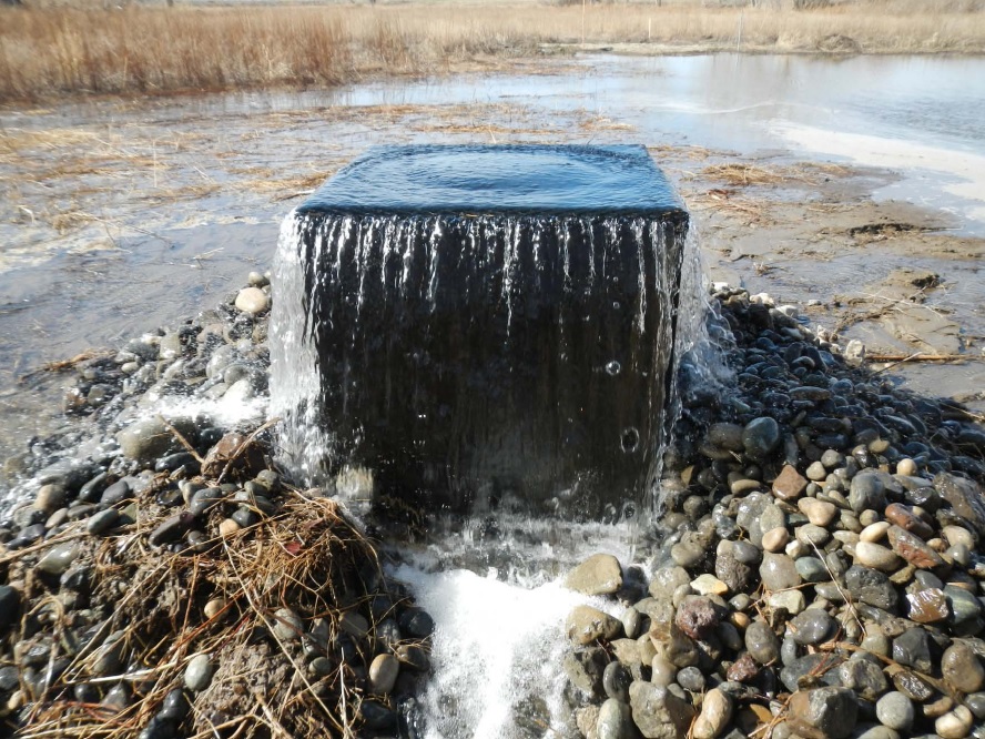
The Locher Road site, located at the intersection of Stateline Road and Locher Road, is a former gravel quarry that has been operated by Gardena Farms Irrigation District #13 (GFID) as an aquifer recharge (AR) site since 2007. From 2006-2007 through the end of the 2010-2011 season, approximately 1/3 acre of the 4+ acre site was utilized for recharge. In late 2011, the site was reconstructed to allow infiltration over a 2.5 acre portion of the site (see photos & designs). Inflow volume rates at the site increased from approximately 1.3 cfs to 3.5-4 cfs. The Locher Road site has operated under successive one and two-year temporary use authorizations issued by Washington Department of Ecology. In addition to the temporary use authorizations, in 2010 the Walla Walla Watershed Management Partnership (WWWMP), a locally led organization that co-manages Walla Walla Basin water resources with the State of Washington, passed a Local Water Plan (LWP) that allows GFID to utilize up to 5 cfs of its existing water right for the purpose of aquifer recharge (visit www.wallawallawatershed.org for more information about local water plans). This authorization, like the temporary use authorization, is governed by the maintenance of minimum instream flows in the river (measured at the Detour Road stream gauge), water quality testing, and hydrologic monitoring in local wells and surface water points. |
|
| Documents | Document Name | Download Documents |
| Project Designs | Click here to download | |
| Project Photos | Click here to view project photos | |
| 2005 Monitoring Plan | Click here to download | |
| 2011 Locher Pumping Test | Click here to download | |
| Gardena Farms Local Water Plan | Click here to download | |
| 2013 Monitoring Plan (QAPP) | Click here to download | |
| Project Annual Reports | Click here to view |
| Contacts & Partners | Name | Role | Organization |
| Stuart Durfee | Site Operations | Gardena Farms Irrigation District #13 | |
| Steven Patten | Project Lead | Walla Walla Basin Watershed Council | |
| Grants & Funding | Organization | Contract # | Funding Amount |
| Washington Department of Ecology (WDOE) | |||
| Walla Walla Watershed Alliance |
| Project Map | |
|
Aquifer Recharge Sites Map |
Mud Creek (WA)
 |
WA Mud Creek Aquifer Recharge Site |
|
Construction Year: 2015 Recharge Seasons: Has not operated |
|
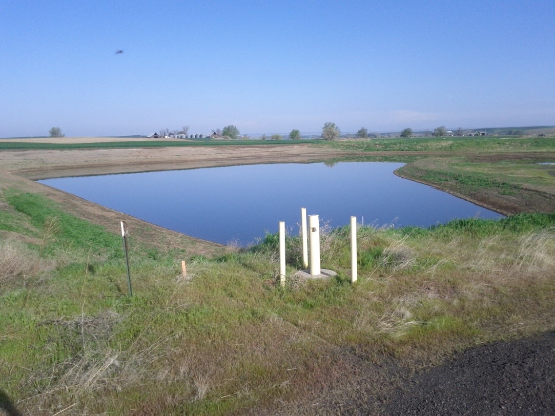
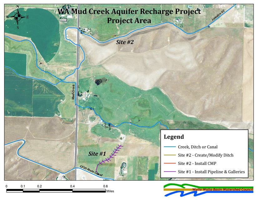
| Project Description | |
|
The WA Mud Creek Aquifer Recharge project, constructed in 2015 with WDOE and BPA funds, is located southeast of Lowden, WA approximately 1.5 miles south of the Walla Walla River and 0.25 miles from Mud Creek. The project is located within Walla Walla County, Section 3, Township 6 North, Range 34 East. This site consists of two different recharge areas. One is an infiltration gallery fed from the Gardena Farms Canal. The second is an infiltration area fed from the Lowden #2 ditch. Each of the sites were constructed to have approximately 1 cfs of recharge water delivered to them. |
|
| Documents | Document Name | Download Documents |
| Project Designs Site #1 | Click here to download | |
| Project Designs Site #2 | Click here to download | |
| Project Photos | Click here for project photos | |
| Grant Agreement | Click here to download |
| Contacts & Partners | Name | Role | Organization |
| Mark Johnson | Site Construction | Harry Johnson Plumbing & Excavating | |
| Steven Patten | Project Lead | Walla Walla Basin Watershed Council | |
| Lance Horning | Project Engineer | Lance Horning Engineering |
| Grants & Funding | Organization | Contract # | Funding Amount |
| Washington Department of Ecology | G1200281 | ||
| Bonneville Power Administration |
| Project Map |
|
|
Aquifer Recharge Sites Map |
Stiller Pond
 |
Stiller Pond Aquifer Recharge Site |
|
Construction Years: 2011 & 2013 Recharge Seasons: 2012, 2014-2017 |
|
| Project Description | |
|
The Stiller Pond alluvial aquifer recharge project is one of several projects in the Walla Walla Basin being done to evaluate alluvial aquifer recharge (AR) methods and effects. The objectives of the Project, like several of the other AR projects in the basin, are to gain experience and information on AR operations, collect information and data that can be used in evaluating the possible effects of AR on alluvial aquifer water levels, and to contribute recharge water to the alluvial aquifer system. Data collected from the Stiller Pond site will be used to address these issues in the immediate area of the Site and contribute to basin-wide planning and water resource management efforts. The Stiller Pond site utilizes an existing basin on the north side of Mill Creek. Water is delivered down a private irrigaiton system to the recharge basin. During the 2014 recharge season, the site was recharge a little over 2 cfs (~1000 gallons per minute) and recharge ~300 acre-feet of water to the alluvial aquifer. The Stiller Pond site operates under a Local Water Plan (LWP - vistit www.wallawallawatershed.org for more information on local water plans) and an Environmental Enhancement Project permit (EEP). |
|
| Documents | Document Name | Download Documents |
| Stiller Pond Local Water Plan | Click here to download | |
| Stiller Pond Hydrogeologic Assessment | Click here to download | |
| Monitoring Well Drilling - Tech Memo | Click here to download | |
| Stiller Pond Preliminary Permit | Click here to download | |
| Stiller Pond Temporary Permit | Click here to download | |
| Stiller Pond Monitoring Plan (2012) | Click here to download | |
| Stiller Pond Monitoring Plan (2014-Present) | Click here to download |
| Contacts & Partners | Name | Role | Organization |
| Greg Kinsinger | Site Operations | Walla Walla County Conservation District | |
| Kevin Lindsey | Hydrogeologist | GSI Water Solutions | |
| Steven Patten | WWBWC Lead | Walla Walla Basin Watershed Council | |
| Chris Hyland | LWP Lead | Walla Walla Watershed Management Partnership |
| Grants & Funding | Organization | Contract # | Funding Amount |
| Washington Department of Ecology (WDOE) | |||
| Bonneville Power Administration (BPA) |
| Project Map | |
|
Aquifer Recharge Sites Map |